- Hello@GeoTech.sa
- (+966) 11- 2101100
About us
We, at GeoTech, provide Geophysical services for: Data acquisition, Interpretation, Processing of Gravity, Micro Gravity, Magnetic, GPR, Resistivity, Electro Magnetic and Project Management, field QC supervision, Topographic surveys.
Geo Surveys
GeoTech is dedicated to delivering the most advanced innovation and technology to our clients active in Civil Engineering, Construction, Public Works, Mines Exploration and engineering industry.
Ground Penetrating Radar Surveys
Electrical Resistivity Survey
Seismic Refraction and MASW Surveys
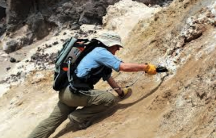
Magnetic & Gravity Surveys
Topographic & Hydrographic Surveys
Electromagnetic Surveys
Non-Destructive Testing
Surveys in detailes
Ground Penetrating Radar, also known as Geo radar or GPR, uses Radar technology to obtain a continuous profile of the subsurface. The basic principle of GPR is simple- An electromagnetic pulse is sent into the medium under investigations. Part of energy gets reflected from an interface across which there is a contrast in dielectric constant, and remaining energy travels further into the medium. The travel time and amplitude information of the returning signal are recorded. Almost continuous transmission of these pulses and recording of returning signal, provides a real time continuous profile of the subsurface. The Georadar is of immense application in areas requiring high resolution information of relatively shallow subsurface. Depth of penetration of radar signal depends on the frequency used and material properties. The application areas of GPR technology include:
- Detection of underground utilities- Pipes, cables (metallic and non-metallic)
- Soil-bedrock interface, shallow geological investigations
- Mining Development
- Mineral Exploration
- Water Table determination
- Glaciology
- Archaeology & Forensics
- Cavities & Voids (Structures- Dams, Bridges, Weirs, Barrages etc.)
- Ground Contaminants (Environment).
- Road Investigations (Layer thickness, Subsidence)
Personnel with GeoTech, have extensively used the technology, and have been involved in its use for dam safety projects in the country. The experts have used GPR for utility mapping of entire cities, for gathering information required prior to taking up any urban infrastructure development project. Company regularly and extensively carries out GPR surveys prior to trench-less drilling (also known as horizontal directional drilling or HDD) for laying of cables and pipes.
Seismic technique is one of the most developed geophysical techniques, providing vital information on subsurface, crucial for most of the engineering projects. GeoTech specializes in Seismic Refraction surveys, routinely carried out for assessment of subsurface conditions prior to engineering projects. The seismic refraction method is based on the measurement of the travel time of seismic waves refracted at the interfaces between layers of different velocities. The seismic energy is generates at shot point using a source (hammer, weight drop, explosive). The energy radiates from shot point, and first arrivals are detected using geophones. The first arrivals can be direct arrivals or refracted arrivals, on different geophones, depending on velocities and thickness of subsurface layers. The time-distance curve is used to determine velocities and thickness of various subsurface layers. The velocity depends on elasticity and density of material through which the energy is traveling, and hence provides information on the material strength, and helps in classification of the material. The seismic refraction surveys are used to determine:
- Bedrock profile, rock quality and depth
- Thickness of overburden
- Fractures and weak zones
- Topography of ground water
- Rippability assessment in mines
- Slope stability studies
- Pipeline route studies
Experts with GeoTech have extensive experience in using seismic refraction for various applications including soil-bedrock continuous profiling in pipeline routes, rippability assessment in mines, slope stability studies in mines, site assessment for power plants, site assessment for land fills etc.
The electrical methods, used for measurement of subsurface resistivity, involve passing an electrical current into the ground using two electrodes, and measuring resultant potential using two potential electrodes. Resistivity sounding involves gradually increasing the spacing between the current and/or potential electrodes to obtain deeper penetration. Under profiling, the electrode spacing is kept constant and the entire arrangement is moved along profile lines, to obtain lateral variation in subsurface resistivity. Electrical resistivity techniques are based on the principle that the resistivity varied depending on the material encountered. Resistivity can then be used to identify different geological units by their electrical properties. If a material’s resistivity value drops it could mean that the rock is water saturated and one can expect to find fractured bedrock. The variation in resistivity will correspond to a geological variation along a investigated line. By calibrating the resistivity results with known geologic materials on site, valuable geotechnical information can be obtained for the dam. This type of survey becomes interesting in determining the weathered bedrock layers and the presence of sand/ moraine under the clay. It also corroborates the information from the refraction results for better geological interpretation. 2D resistivity imaging uses an array of electrodes connected by multicore cable to provide a linear depth profile of the variation in resistivity both along the survey line and with depth. The acquisition system consists of two units connected to a laptop computer. One unit is a resistivity meter which injects the electrical current into the ground and measures the voltage between the electrodes. The other unit is a control switch box which selects both the injection electrode pair and the potential electrode pair for each datapoint . The data are presented as pseudo-section in which the spatial distribution of the electric properties of the investigated material can be qualified. To qualify the data , a modeling routine is applied to the dataset according to the Zohdy method. This new section can be correlated to a depth section since the Zohdy method computes from the datapoint a series of continuous vertical electrical profiles. The Electrical surveys of used in civil engineering, water resources, mining and environmental projects to:
- Determine the underground water resources
- Bedrock quality and depth measurements
- Mineral prospecting
- Dam structure analysis
- Landfill
- Contamination source detection
Experts with GeoTech have been regularly involved in electrical surveys for ground water prospecting and other applications. The experts have used electrical imaging for site assessment (underground storage tanks), dam structure assessment and various related fields.
Borehole seismic tomography is used to derive an image of seismic velocity between two or more boreholes by measuring travel time between source and receivers along various raypaths. The technique is used for detailed and targeted evaluation of material. One hole is used as source hole, and for wave generated at various depths in this hole, travel times are measures at number of receivers in the other hole, also known as receiver hole. This yields a network of overlapping raypaths, which are used in computations to create a velocity image, also known as tomogram. The tomogram helps identifying anomalous zones, which are visible as velocity contrasts. The application areas of seismic tomography are:
- Identification of features like fault zones and voids.
- Mapping of loose zones, sinkholes, anomalous zones in structures like dams
- Detailed study of old foundations
Experts with GeoTech have been involved in high resolution seismic tomography for various projects in the country, and have used it for number of new application areas.
Crosshole seismic surveys are used to derive information on the elastic properties of materials between two or more boreholes by measuring travel time of seismic energy. One hole is used as shot hole, and another hole as receiver hole, and travel time from source to receiver is measures at different depths. Using P & S wave travel times, dynamic moduli are calculated.
GeoTech carries out topographic and hydrographic surveys for various applications:
- Roads & Highways
- Pipeline, canal, powerline route study
- Site plan preparation
- Cadastral Surveys
- DTM Generation
- River Modeling
- Dam Break analysis
- Reservoir sedimentation studies
- Dredging Monitoring
- Inundation Mapping
The surveys are carried out using latest instruments like GPS, Total Stations, Autolevels, etc.
Magnetics Surveys:
Magnetometer surveys are rapid and efficient. Magnetometers can be used to detect buried ferrous metal objects (tanks or drums) or bedrock features with contrasting magnetite content. Detection depends on the amount of magnetic material present and its distance from the sensor. A single steel drum can be detected at burial depths up to 15 or 20 feet. Burial depth can be estimated from magnetometer data collected using the gradient method.
It is applied for the following applications;s
- location of buried tanks and drums
- geologic mapping
- mineral exploration
- archaeology
Constraints: Utilities, power lines, buildings, and metallic debris can cause interference. Solar magnetic storms may cause fluctuations in readings. The size and depth of objects affect detectability.
Method: When a ferrous material is placed within a magnetic field such as the earth's, it develops an induced magnetic field. The induced field is superimposed on the earth's field at that location creating a magnetic anomaly. A magnetometer survey for hydrogeologic and engineering applications is conducted on foot, by one operator. The survey can be along single lines or along a series of parallel traverses with readings taken every 5 to 50 feet. Spacing of traverses and readings depends on the width of the expected anomaly. For instance, tank searches may be conducted at a 5-foot spacing while geologic mapping may be conducted at a 50-foot spacing. The results of our magnetometer surveys are presented to the client in a full report that generally includes magnetic profiles, and an index map showing locations of magnetic anomalies. Magnetic contour maps and other graphic presentations are also available
Gravity Surveys:
Gravity surveys can provide useful information where other methods do not work. For example, gravity may be used to map bedrock topography under a landfill, where seismic refraction is limited. Gravity can also be used to map lateral lithologic changes, and faults.
It is applied for the following purposes:
- bedrock topography under landfills.
- mapping large metallic mineral deposits.
- locating subsurface caverns, cavities.
- locating contacts between geologic units of differing mass and density.
Constraints: Utilities, power lines, buildings, and metallic debris can cause interference. Solar magnetic storms may cause fluctuations in readings. The size and depth of objects affect detectability. Method: When a ferrous material is placed within a magnetic field such as the earth's, it develops an induced magnetic field. The induced field is superimposed on the earth's field at that location creating a magnetic anomaly. A magnetometer survey for hydrogeologic and engineering applications is conducted on foot, by one operator. The survey can be along single lines or along a series of parallel traverses with readings taken every 5 to 50 feet. Spacing of traverses and readings depends on the width of the expected anomaly. For instance, tank searches may be conducted at a 5-foot spacing while geologic mapping may be conducted at a 50-foot spacing. The results of our magnetometer surveys are presented to the client in a full report that generally includes magnetic profiles, and an index map showing locations of magnetic anomalies. Magnetic contour maps and other graphic presentations are also available Constraints: Gravity surveys are relatively slow and expensive. Detectability varies with target size, depth and density contrast. Interpretation of data often requires control data from drilling, outcrops, or other sources. Detailed surface topographic survey data is also required.
Method: Gravity is the attraction between masses. The strength of this force is a result of the mass and distance separating the objects. A gravimeter is used to measure the earth's gravitational attraction at various points over the area of interest. Gravity anomalies are due to differences in density of underlying materials. Gravity anomalies are extremely small relative to the total field and are usually measured in micro-Gals (one micro-Gal is about 1 billionth of the earth's total gravitational field). The equipment used in a gravity survey is extremely delicate and precise. Data interpretation is time consuming even with the use of sophisticated computer programs. Results are presented in a full report which includes profiles or a contour map and gravity data tables.
- Rebar Detections/Cover meter.
- Concrete Hammer Test.
- Moisture and corrosion analysis in Concrete.
- Ultrasonic Testing.
- Chloride test.
- Welding Inspections.
- Bond Test.
- Capo-test.
- Hum-Meter.
- Rainbow Indicator ( For carbonation depth and PH).
Our Services
Nulla vulputate venenatis orci, a laoreet libero vehicula ac.
Investigations.
Exploration
Evaluation.
Services In Detailes
Civil Engineering:
All large projects of civil engineering require precise information of subsurface, like overburden thickness, profile of bedrock, quality and strength of foundation etc.Geophysical methods provide quick, economical and continuous information on the area of study, and considerably reduce the drilling budget and remove ambiguity to a large extent.
- Foundation Studies- dams, towers, bridges, high rise buildings.
- Bedrock Properties &Overburden Mapping.
- Tunnel Route Investigations.
- Underground Cavities and Utilties Detection.
Minerals exploration:
- Ore body mapping.
- Rippability/ excavability studies.
- Slope stability studies.
- Vibration Monitoring.
- Ground water studies.
Ground Water:
- Ground water Investigations.
- Ground water modeling .
- Water contamination studies.
Road Condition Evaluation:
- Subsurface settlement studies.
- Precise determination of thickness of various layers.
- Quality control & vigilance.
Topographic Surveys:
- Cadastral Surveys.
- Road, railways, canal alignment surveys.
- River, reservoir surveys.
GIS Services:
- Agriculture and Soil resources.
- Land use/Land cover/Land Degradation.
- Forest.
Some of our tools
-
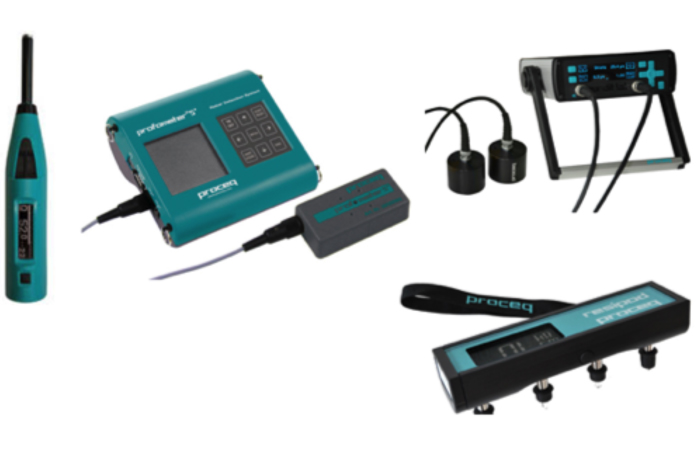
NDT Surveys Equipment
-
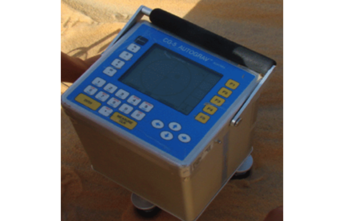
Gravitymeter
-

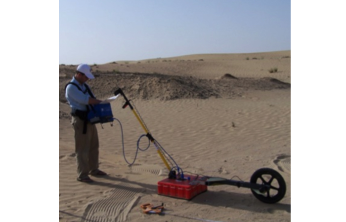
Electrical Resistivity Equipment
-
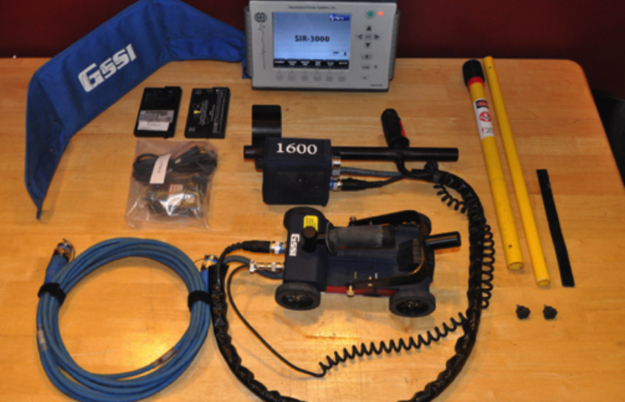
Ground Penetration Radar (GPR)
-
GPR for Concrete Scanning
-
Rocks and Minerals Exploration